일반적인 기하 변환
imwarp 워크플로를 사용하여 일반적인 기하 변환 수행기하 변환은 출력 영상의 픽셀 좌표를 입력 영상의 좌표로 매핑합니다. 그런 다음, 매핑 과정에서 입력 영상의 출력 픽셀 값이 보간됩니다.
다음 함수를 사용하여 일반적인 2차원, 3차원 및 N차원 기하 변환을 수행할 수 있습니다. 2차원 또는 3차원 기하 변환을 수행하려면 먼저 변환에 대한 정보를 저장하는 기하 변환 객체를 만드십시오. 그런 다음, 변환할 영상과 기하 변환 객체를 imwarp 함수에 전달합니다.
함수
도움말 항목
기하 변환
- 2차원과 3차원 기하 변환 과정 개요
2차원 또는 3차원 영상의 일반 기하 변환을 수행하기 위해, 먼저 변환 파라미터를 정의한 후 영상을 워핑합니다. - 기하 변환의 행렬 표현
요소가 변환 파라미터를 나타내는 행렬을 사용하여 평행 이동, 스케일링, 회전, 반사와 같은 기하 변환을 나타냅니다. - Migrate Geometric Transformations to Premultiply Convention
Starting in R2022b, functions that create and perform geometric transformations were updated to use a premultiply matrix convention. - N-Dimensional Spatial Transformations
You can create custom geometric transformations to process images of arbitrary dimension, or to change the dimensionality of the output image from the input image. - Specify Fill Values in Geometric Transformation Output
Specify the color of blank space in the image after a geometric transformation.
공간 참조
- 영상 좌표계
이산 픽셀 인덱스와 연속 공간 좌표를 사용하여 영상 위치를 표시하는 방법을 알아봅니다. - Define World Coordinate System of Image
Spatial referencing objects encode the relationship between the image extent in intrinsic coordinates, the image extent in world coordinates, and the image resolution. - 표시된 영상의 x 좌표와 y 좌표 범위 이동하기
이 예제에서는 표시된 영상의XData와YData속성을 변경하여 디폴트가 아닌 세계 좌표계를 지정하는 방법을 보여줍니다.
추천 예제
Create Composite 2-D Affine Transformations
Combine multiple affine geometric transformations using matrix multiplication.

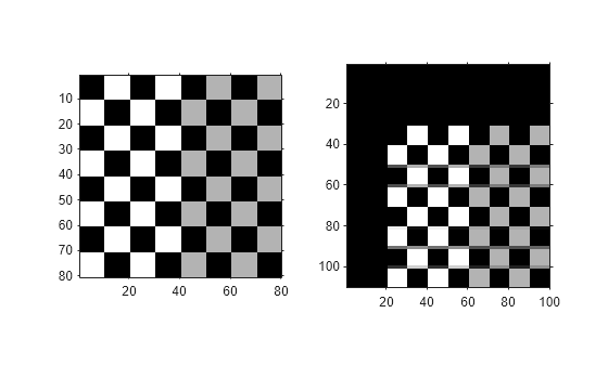
Create a Gallery of Transformed Images
Warp a test image using several built-in and custom geometric transformations, including affine, projective, polynomial, piecewise linear, sinusoidal, barrel, and pin-cushion transformations.
Perform Simple 2-D Translation Transformation
Shift an image vertically and horizontally, and use spatial referencing information to display the original image and the translated image from the same perspective.