시나리오 생성 및 시각화
궤도의 위성을 모델링 및 시각화하고 지상국과의 액세스 계산과 같은 추가 분석을 수행하기 위한 위성 시나리오를 만듭니다.
객체
satelliteScenario | 위성 시나리오 |
satelliteScenarioViewer | 위성 시나리오에 대한 뷰어 만들기 |
Satellite | 위성 시나리오의 위성 |
Platform | Platform in satellite scenario (R2024a 이후) |
GroundStation | Ground station object belonging to satellite scenario |
ConicalSensor | Conical sensor object belonging to satellite scenario |
GroundTrack | Ground track object belonging to satellite or platform in scenario |
Transmitter | Transmitter object belonging to satellite scenario |
Receiver | Receiver object belonging to satellite scenario |
Pattern | Radiation pattern visualization (R2021b 이후) |
Gimbal | Gimbal object belonging to satellite scenario |
Access | Access analysis object belonging to scenario |
FieldOfView | Field of view object belonging to satellite scenario |
Link | 송신기에 속한 링크 분석 객체 |
Orbit | Orbit visualization satellite object (R2024a 이후) |
geoTrajectory | Waypoint trajectory in geodetic coordinates (R2024a 이후) |
quaternion | 쿼터니언 배열 생성 (R2024a 이후) |
함수
도움말 항목
- 위성 시나리오 기본 사항
완전한 위성 시나리오 시뮬레이션을 빌드합니다.
- 위성 시나리오 핵심 개념
일반적인 위성 시나리오 시각화 용어를 알아봅니다.
추천 예제
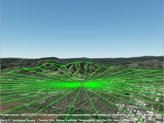
Satellite Visibility Analysis Using Terrain
Analyze satellite visibility from a ground station using a visibility mask computed from the surrounding terrain. A visibility mask is a set of azimuth and elevation angles that define where obstructions block a satellite's line-of-sight visibility.
위성군에 대한 커버리지 지도
satelliteScenario와 2차원 지도를 사용하여 관심 영역에 대한 커버리지 지도를 표시합니다.

항공기에서 위성으로의 ADS-B Out 통신
비행에서의 ADS-B Out 연결을 살펴봅니다.

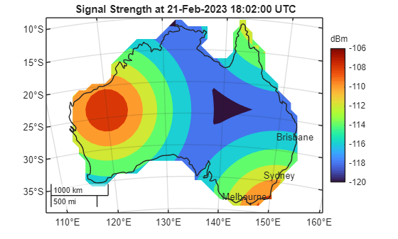
Analyze NTN Coverage and Capacity for LEO Mega-Constellation
Analyze coverage and capacity of a very low population density region for LEO mega-constellation for satellite-based NTN applications.

Multi-Hop Satellite Communications Link Between Two Ground Stations
Set up multi-hop link between two ground stations.

위성군의 지상국 액세스
지상국과 위성군에 탑재된 원뿔형 센서 간의 액세스 분석을 설정합니다.

Comparison of Orbit Propagators
Compare the orbits predicted by the Two-Body-Keplerian, SGP4, and SDP4 orbit propagators.

Calculate Latency and Doppler in a Satellite Scenario
Model and calculate the latency and Doppler frequencies between the satellite and the ground station.

Modeling Satellite Constellations Using Ephemeris Data
Add time-stamped ephemeris data for a constellation of satellites to a satellite scenario for access analysis.

Interference from Satellite Constellation on Communications Link
Analyze interference on a downlink from a constellation of satellites.

Estimate GNSS Receiver Position with Simulated Satellite Constellations
Track the position of a ground vehicle using a simulated Global Navigation Satellite System (GNSS) receiver.

Multi-Hop Path Selection Through Large Satellite Constellation
Select the multi-hop path through large satellite constellation to gain access between two ground stations.

Modeling Custom Satellite Attitude and Gimbal Steering
Point satellite or gimbal in satellite scenario using logged orientation data from
timetable or timeseries.

Location-Based Analysis of Visible GPS Satellites
Analyze the visible GPS satellites from a particular location using
satelliteScenario.

Iridium Satellite Spot Beam Coverage on the US
Generate and visualize Iridium satellite spot beams on the US map.