Generate Scenario from Recorded GPS and Lidar Data
This example shows how to generate a driving scenario by extracting recorded data from global positioning systems (GPS) and lidar sensors mounted on an ego vehicle. In this example, you use prerecorded sensor data and follow these steps to generate the scenario:
Read data from the GPS sensor. Use the GPS data to:
Import the map data from OpenStreetMap®.
Extract the road information and driving route from the imported map data.
Compute the waypoints for the ego vehicle.
Estimate the ego speed and trajectory.
Read data from the lidar sensor. Use the lidar data to:
Find the dimension and the type of non-ego actors in the driving scene.
Estimate the entry times, exit times, positions, velocities, speeds, yaws, and trajectories of non-ego actors by using the lidar data.
Generate the driving scenario by using the extracted road network and the estimated ego and non-ego data.
Read GPS Sensor Data
Create a folder in the temporary directory on your computer to store the sensor data.
sensorData = fullfile(tempdir,"AutomotiveDataset");
if ~isfolder(sensorData)
    mkdir(sensorData)
end
Download the .mat file containing the recorded GPS sensor data and save it to a specified folder in the temporary directory. Load the GPS sensor data from the .mat file into the MATLAB® workspace.
if ~exist("data","var")
    url = "https://ssd.mathworks.com/supportfiles/driving/data/highwayLaneChangeDatase/ins2.mat";
    filePath = fullfile(sensorData,"ins.mat");
    if ~isfile(filePath)
        websave(filePath,url);
    end
    data = load(filePath);
end
Display the GPS sensor data. The data is stored as a structure with fields timeStamp, velocity, yawRate, latitude, longitude, and altitude. The latitude and the longitude coordinates specify the driving route of the ego vehicle.
data.ins
ans=1×1158 struct array with fields:
    1461634404927776    27.6796        -0.0022    45.5336    -122.6252    28.7056
    1461634404977663    27.6796        -0.0033    45.5336    -122.6252    28.6953
    1461634405027158    27.6796        -0.0037    45.5336    -122.6252    28.6966
    1461634405078119    27.6802        -0.0011    45.5336    -122.6252    28.7133
    1461634405127767    27.6789    -7.6891e-05    45.5336    -122.6252    28.7402
    1461634405177444    27.6762        -0.0015    45.5336    -122.6252    28.7339
    1461634405228158    27.6742        -0.0017    45.5336    -122.6251    28.7588
    1461634405277898    27.6747        -0.0010    45.5336    -122.6251    28.8033
    1461634405328297    27.6745        -0.0023    45.5336    -122.6251    28.8394
    1461634405377230    27.6757        -0.0020    45.5336    -122.6251    28.8744
    1461634405427324    27.6743        -0.0037    45.5336    -122.6251    28.8439
    1461634405477538    27.6740        -0.0010    45.5336    -122.6251    28.8413
    1461634405527309    27.6742     5.5854e-05    45.5336    -122.6250    28.8709
    1461634405577470    27.6745         0.0019    45.5336    -122.6250    28.9130
Select a part of the recorded sensor data by specifying start and end timestamp values. Units are in microseconds. Typically, the units depend on the data logging configuration of the sensors.
sim.startTime = 1461634424950000;
sim.endTime = 1461634434950000;
Compute the number of data points within the specified start and end timestamps. Also, find the start and end indices of the timestamps by using the helperTimestampIndex function.
[count.gps,sim.gps.startstep,sim.gps.endstep] = helperTimestampIndex([data.ins.timeStamp].',sim.startTime,sim.endTime);
Extract the timestamp, latitude, longitude, and elevation parameters of all data points between the start and end indices. Store the extracted parameters in a table.
data.ins = data.ins(sim.gps.startstep : sim.gps.endstep);
gps = table([data.ins.timeStamp].',[data.ins.latitude].',[data.ins.longitude].',[data.ins.altitude].',VariableNames=["timestamp","lat","lon","elevation"]);
Extract Road Network Using GPS Sensor Data
Specify the minimum and maximum values of the latitude and longitude coordinates, for the selected data, to download a road network using the OpenStreetMap® website. You can also specify an offset value in order to extract extended map data that lies within the range of the GPS sensor.
map.gpsExtend = 0.0001;
map.minLat = min(gps.lat) - map.gpsExtend;
map.maxLat = max(gps.lat) + map.gpsExtend;
map.minLon = min(gps.lon) - map.gpsExtend;
map.maxLon = max(gps.lon) + map.gpsExtend;
Download the map data from the OpenStreetMap® website https://www.openstreetmap.org, which provides access to crowd-sourced map data from all over the world. The data is licensed under the Open Data Commons Open Database License (ODbL), https://opendatacommons.org/licenses/odbl/.
Extract the map data from within the minimum and maximum latitude and longitude coordinates. Specify a file name to save the downloaded map data. In this example, the file name is set as the name of a road in the driving route.
url = ['https://api.openstreetmap.org/api/0.6/map?bbox=' ...
    num2str(map.minLon, '%.10f') ',' num2str(map.minLat,'%.10f') ',' ...
    num2str(map.maxLon, '%.10f') ',' num2str(map.maxLat,'%.10f')];
fileName = "BanfieldFreeway.osm";
websave(fileName,url,weboptions(ContentType="xml"));
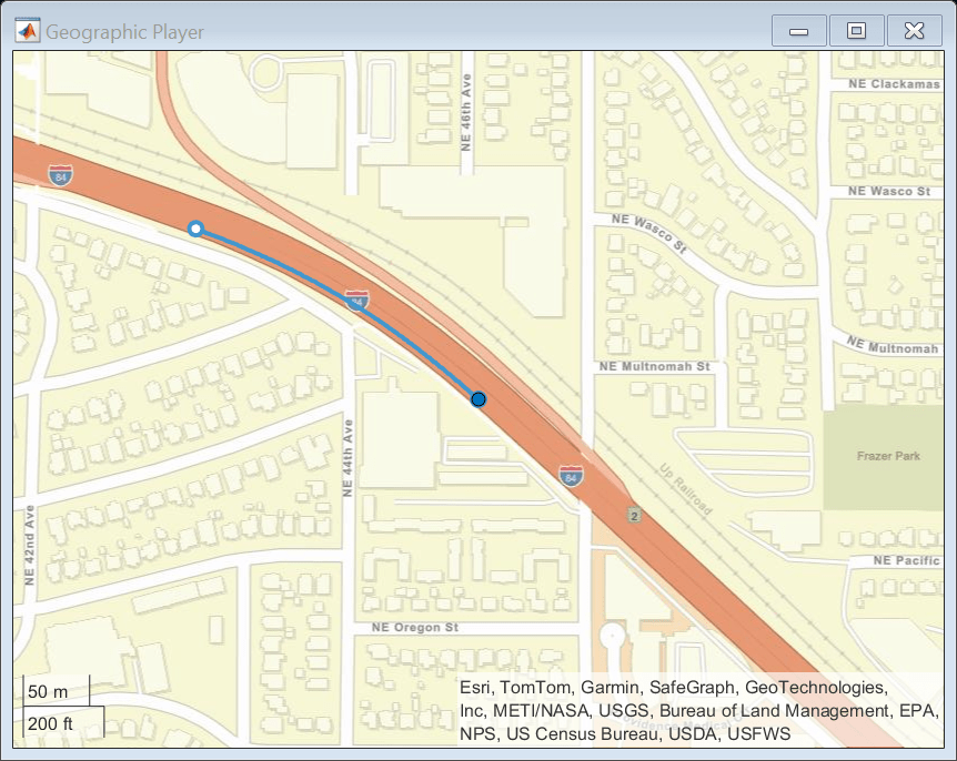
Plot the driving route on a map by using the geoPlayer function.
map.midLat = (map.minLat + map.maxLat)/2;
map.midLon = (map.minLon + map.maxLon)/2;
zoomLevel = 17;
player = geoplayer(map.midLat,map.midLon,zoomLevel);
figure
plotRoute(player,gps.lat,gps.lon);
for i = 1:count.gps
    plotPosition(player,gps.lat(i),gps.lon(i));
end
Get Road Information from Extracted Road Network
To get information from the extracted road network, you must first import the map data to a drivingScenario object. Then, use the helperGetRoadHistoryAttributes function to extract the road information.
Compute the total simulation time by using the start and end timestamps of the GPS data. Units are in seconds.
sim.TotalTime = (sim.endTime - sim.startTime)/10^6;
Specify the sample time for the driving scenario. The sample time is the time interval between scenario simulation steps, and also defines the sample time for the ego vehicle. Units are in seconds.
sim.egoSampleTime = 0.01;
Create an empty driving scenario object by using the drivingScenario function.
importedScenario = drivingScenario(SampleTime=sim.egoSampleTime,StopTime=sim.TotalTime);
Import the extracted map data to the driving scenario by using the roadNetwork function.
roadNetwork(importedScenario,OpenStreetMap=fileName);
Read the road information stored in the scenario object by using the helperGetRoadHistoryAttributes function. The road properties include the road centers, road width, banking angles, lane specifications, and road names.
[roadCenters,roadWidth,bankingAngles,laneSpec,roadNames] = helperGetRoadHistoryAttributes(importedScenario);
Create Driving Scenario and Add Roads to Scenario
Create a new drivingScenario object and add roads to the new scenario. Set the properties of these roads by using the extracted road information.
Specify the sample time for the new scenario.
sim.sampleTime = 0.1;
scenario = drivingScenario(SampleTime=sim.sampleTime,StopTime=sim.TotalTime);
Specify a georeference point and use the latlon2local function to convert the GPS sensor data from GPS coordinates to local east-north-up Cartesian coordinates.
refPoint = [map.midLat map.midLon,0];
[gps.x,gps.y,gps.elevation] = latlon2local(gps.lat,gps.lon,gps.elevation,refPoint);
filteredData = smoothdata([gps.x,gps.y gps.elevation],'sgolay');
gps.x = filteredData(:,1);
gps.y = filteredData(:,2);
gps.elevation = filteredData(:,3);
Specify a bounding box that define the range for the map coordinates.
map.localExtend = 70;
map.xmin = min(gps.x) - map.localExtend;
map.xmax = max(gps.x) + map.localExtend;
map.ymin = min(gps.y) - map.localExtend;
map.ymax = max(gps.y) + map.localExtend;
Specify the names of the roads in the exported road network to be added to the scenario. You can find the names of the roads in the roadNames output of the helperGetRoadHistoryAttributes function.
map.keepRoads = "Banfield Freeway";Check if the desired roads are within the bounding box and, if they are, add them to the driving scenario.
for i = 1:size(roadNames,1)
    flag = 0;
    for j = 1: size(map.keepRoads,1)
        if contains(roadNames{i,1},map.keepRoads(j,1),IgnoreCase=true)
            flag = 1;
        end
    end
    if flag
        k = 0;
        for l = 1:size(roadCenters{i,1},1)
            k = k+1;
            % Remove road centers that lie outside the bounding box.
            if roadCenters{i,1}(k,1) < map.xmin || ...
                    roadCenters{i,1}(k,1) > map.xmax || ...
                    roadCenters{i,1}(k,2) < map.ymin || ...
                    roadCenters{i,1}(k,2) > map.ymax
                roadCenters{i,1}(k,:) = [];
                k = k-1;
            end
        end
        if k > 1
            % Add roads by using the road centers. Set the road width to 12.
            roadwidth = 12;
            road(scenario,roadCenters{i,1},roadwidth,Name=roadNames{i,1});
        end
    end
end
Compute Ego Data Using GPS Sensor Data
The GPS sensor data corresponds to the ego vehicle, so you can use the GPS measurements to compute the ego vehicle waypoints and speed.
The latitude and longitude values specify the waypoints for the ego vehicle in GPS coordinates. Compute the GPS time relative to the start time of the simulation and find the ego speed value at each waypoint.
gps.relativeTime = double(gps.timestamp - sim.startTime)/10^6;
Add the ego vehicle to the imported road network and compute its trajectory.
egoVehicleGPS = vehicle(importedScenario,ClassID=1,Position=[gps.x(1),gps.y(1),0]);
trajectory(egoVehicleGPS,[gps.x,gps.y,zeros(count.gps,1)],TimeofArrival=gps.relativeTime);
Extract information about the position, velocity, and yaw of the ego vehicle from the imported scenario by using the actorPoses function.
positionIndex = [1 3 6];
velocityIndex = [2 4 7];
i = 1;
while advance(importedScenario)
    position(1,:) = actorPoses(importedScenario).Position;
    simEgo.data(i,positionIndex) = position;
    velocity(1,:) = actorPoses(importedScenario).Velocity;
    simEgo.data(i,velocityIndex) = velocity;
    simEgo.data(i,5) = i;
    yaw = actorPoses(importedScenario).Yaw;
    simEgo.data(i,8) = yaw;
    simEgo.data(i,9) = importedScenario.SimulationTime;
    i = i + 1;
end
The computed ego data values include the time, waypoints, velocity, and yaw of the ego vehicle. Store the ego data to a table and inspect the values.
table(simEgo.data(:,9),simEgo.data(:,positionIndex), ...
    simEgo.data(:,velocityIndex),simEgo.data(:,8), ...
    VariableNames=["Time","Waypoints","Velocity","Yaw"])
ans=997×4 table
    0.0100    -106.8059    64.5263    0    23.9545    -8.6128    0    -19.7759
    0.0200    -106.8059    64.5263    0    23.9652    -8.6166    0    -19.7759
    0.0300    -106.7683    64.5128    0    23.9758    -8.6205    0    -19.7760
    0.0400    -106.5285    64.4266    0    23.9859    -8.6259    0    -19.7798
    0.0500    -106.2886    64.3403    0    23.9951    -8.6337    0    -19.7893
    0.0600    -106.0486    64.2539    0    24.0034    -8.6439    0    -19.8046
    0.0700    -105.8085    64.1674    0    24.0108    -8.6566    0    -19.8257
    0.0800    -105.5684    64.0807    0    24.0207    -8.6728    0    -19.8525
    0.0900    -105.3281    63.9939    0    24.0400    -8.6930    0    -19.8803
    0.1000    -105.0876    63.9069    0    24.0466    -8.7078    0    -19.9065
    0.1100    -104.8472    63.8198    0    24.0405    -8.7174    0    -19.9312
    0.1200    -104.6068    63.7326    0    24.0218    -8.7215    0    -19.9543
    0.1300    -104.3668    63.6453    0    23.9979    -8.7231    0    -19.9759
    0.1400    -104.1268    63.5581    0    23.9958    -8.7324    0    -19.9972
      ⋮
Add Ego and Non-Ego Actors to Scenario
To add ego and non-ego actors to the scenario:
Read data recorded by lidar sensor.
Estimate the position, velocity, speed, and yaw for the ego vehicle by considering both GPS and lidar timestamps. Compute the ego trajectory.
Find the number of non-ego actors in the scenario. Compute their waypoints, velocities, speeds, and yaws by using the recorded lidar sensor. Compute the trajectories of the non-ego actors.
Convert the waypoints of the non-ego actors from the ego frame to the scenario frame.
Add the ego and non-ego actors to the driving scenario.
Read Lidar Sensor Data
Download the .mat file containing the recorded lidar sensor data and save it to a specified folder in the temporary directory. Load the lidar sensor data from the .mat file into the MATLAB workspace.
if ~exist("newData","var")
    url = "https://ssd.mathworks.com/supportfiles/driving/data/highwayLaneChangeDatase/lidar2.mat";
    filePath = fullfile(sensorData,'lidar.mat');
    if ~isfile(filePath)
        websave(filePath,url);
    end
    newData = load(filePath);
end
Compute the number of data points within the specified start and end timestamps. Also, find start and end indices of the timestamps by using the helperTimestampIndex function.
[count.lidar,sim.lidar.startstep,sim.lidar.endstep] = helperTimestampIndex([newData.lidar.timeStamp].',sim.startTime,sim.endTime);
Extract the timestamp and point cloud data that lies between the start and end indices. Store the extracted parameters in a table.
newData.lidar = newData.lidar(sim.lidar.startstep : sim.lidar.endstep);
lidar = table([newData.lidar.timeStamp].',{newData.lidar.ptCloud}.',VariableNames=["timestamp","ptCloud"])lidar=100×2 table
1461634425028360 1×1 pointCloud
1461634425128114 1×1 pointCloud
1461634425228122 1×1 pointCloud
1461634425327849 1×1 pointCloud
1461634425427574 1×1 pointCloud
1461634425528347 1×1 pointCloud
1461634425627513 1×1 pointCloud
1461634425728613 1×1 pointCloud
1461634425828486 1×1 pointCloud
1461634425928594 1×1 pointCloud
1461634426028230 1×1 pointCloud
1461634426128400 1×1 pointCloud
1461634426228515 1×1 pointCloud
1461634426327968 1×1 pointCloud
⋮
Estimate Ego Data With Regard to GPS and Lidar Timestamps
Find the lidar timestamps relative to the start time of the simulation. Units are in seconds.
lidar.relativeTime = double(lidar.timestamp - sim.startTime)/10^6;
Find the ego position, velocity, speed, and yaw by using the ego data from the GPS measurements as reference.
temp = zeros(1,9);
i = 1;
for j = 2 : size(simEgo.data,1)
    t = simEgo.data(j,9);
    if i <= count.lidar && lidar.relativeTime(i) <= t
        tratio = (t - lidar.relativeTime(i)) / (t - simEgo.data(j-1,9));
        for k = [1:4,8]
            temp(1,k) = simEgo.data(j,k) - ...
                ((simEgo.data(j,k) - simEgo.data(j-1,k))*tratio);
        end
        ego.position(i,:) = temp(1,positionIndex);
        ego.velocity(i,:) = temp(1,velocityIndex);
        ego.speed(i,:) = sqrt(temp(1,2)^2 + temp(1,4)^2);
        ego.yaw(i,:) = temp(1,8);
        i = i + 1;
    elseif i == count.lidar && size(simEgo.data,1) == j
        ego.position(i,:) = simEgo.data(j,positionIndex);
        ego.velocity(i,:) = simEgo.data(j,velocityIndex);
        ego.speed(i,:) = sqrt(simEgo.data(j,2)^2 + simEgo.data(j,4)^2);
        ego.yaw(i,:) = simEgo.data(j,8);
    end
end
ego.position = smoothdata(ego.position,'sgolay');
ego.yaw = smoothdata(ego.yaw);
Add Ego Vehicle to Scenario
Add the ego vehicle to the driving scenario and compute its trajectory.
egoVehicle = vehicle(scenario,ClassID=1,Position=ego.position(1,:),Yaw=ego.yaw(1), ...
    Mesh=driving.scenario.carMesh);
trajectory(egoVehicle,ego.position,TimeofArrival=lidar.relativeTime,Yaw=ego.yaw);
Estimate Non-Ego Data
Create a track list from the lidar point cloud data by using the helperPointCloudToTracks function. The track list contains information about the objects detected in the point cloud data.
if ~exist("trackList","var")
    trackList.object = helperPointCloudToTracks(lidar.ptCloud);
    trackList.timestamp = lidar.timestamp;
    trackList.relativeTime = lidar.relativeTime;
    for i = 1:count.lidar
        trackList.nObj(i,1) = size(trackList.object{i,1},1);
    end
end
Convert the track list data to non-ego data by using the helperComputeNonEgoData function. The function computes the dimensions, entry times, exit times, yaws, and speeds of the non-ego actors in the scenario. The function also converts the positions of the non-ego actors computed in the ego frame to scenario or map frame, and then smooths the position values.
[count.nonEgo,nonEgo] = helperComputeNonEgoData(trackList,count,ego)
count = struct with fields:
       gps: 200
     lidar: 100
    nonEgo: 6
nonEgo=6×18 table
    94      37    4.6931    1.7953    1.4510    100     7    0.7000    100    10.0000    1    1×1 extendedObjectMesh    94×3 double    94×1 double    94×1 double    94×3 double    94×1 double    94×3 double
    45      38    4.6931    1.7932    1.4241     51     7    0.7000     51     5.1000    1    1×1 extendedObjectMesh    45×3 double    45×1 double    45×1 double    45×3 double    45×1 double    45×3 double
    94      49    4.6942    1.7974    1.4007    100     7    0.7000    100    10.0000    1    1×1 extendedObjectMesh    94×3 double    94×1 double    94×1 double    94×3 double    94×1 double    94×3 double
    28      99    4.6924    1.7942    1.3990     34     8    0.8000     35     3.5000    1    1×1 extendedObjectMesh    28×3 double    28×1 double    28×1 double    28×3 double    28×1 double    28×3 double
    44     940    4.6938    1.7981    1.4171     50    54    5.4000     97     9.7000    1    1×1 extendedObjectMesh    44×3 double    44×1 double    44×1 double    44×3 double    44×1 double    44×3 double
    42    1021    4.6928    1.7965    1.4271     48    59    5.9000    100    10.0000    1    1×1 extendedObjectMesh    42×3 double    42×1 double    42×1 double    42×3 double    42×1 double    42×3 double
Add Non-Ego Actors to Scenario
Add the non-ego actors to the driving scenario and compute their trajectories.
for i= 1:count.nonEgo
    if nonEgo.classID(i) == 1
        nonEgoVehicle(i) = vehicle(scenario, ...
            ClassID=nonEgo.classID(i),Name=nonEgo.id(i,:), ...
            Position=nonEgo.smoothPos{i,1}(1,:), ...
            Length=nonEgo.length(i,1),Width=nonEgo.width(i,1), ...
            Height=nonEgo.height(i,1),Mesh=nonEgo.mesh(i,1), ...
            EntryTime=nonEgo.entryTime(i,1), ...
            ExitTime=nonEgo.exitTime(i,1));
    else
        nonEgoVehicle(i) = actor(scenario, ...
            ClassID=nonEgo.classID(i),Name=nonEgo.id(i,:), ...
            Position=nonEgo.smoothPos{i,1}(1,:), ...
            Length=nonEgo.length(i,1),Width=nonEgo.width(i,1), ...
            Height=nonEgo.height(i,1),Mesh=nonEgo.mesh(i,1), ...
            EntryTime=nonEgo.entryTime(i,1), ...
            ExitTime=nonEgo.exitTime(i,1));
    end
    trajectory(nonEgoVehicle(i),nonEgo.smoothPos{i,1},TimeOfArrival=nonEgo.time{i,1});
end
Simulate and Visualize Generated Scenario
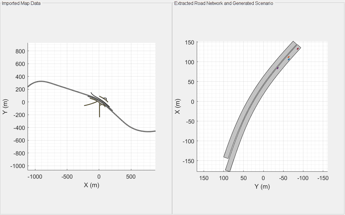
Plot the map data and the scenario generated using GPS and lidar sensor data.
scfig = figure(Position=[0,0,800,500]);
hfig = uipanel(scfig,Title="Imported Map Data",Position=[0 0 0.5 1]);
plaxis = axes(hfig);
plot(importedScenario,Parent=plaxis)
hfig1 = uipanel(scfig,Title="Extracted Road Network and Generated Scenario",Position=[0.5 0 0.5 1]);
plaxis1 = axes(hfig1);
plot(scenario,Parent=plaxis1);
xlim([-100,100])
while advance(scenario)
    pause(sim.sampleTime);
end
You can also visually inspect the accuracy of the generated scenario by plotting it alongside the camera sensor and lidar sensor data.
Read the data recorded by camera sensor.
if ~exist("camera","var")
    url = "https://ssd.mathworks.com/supportfiles/driving/data/highwayLaneChangeDatase/camera2.mat";
    filePath = fullfile(sensorData,"camera.mat");
    if ~isfile(filePath)
        websave(filePath,url);
    end
    img = load(filePath,"imageData");
    [count.camera,sim.camera.startstep,sim.camera.endstep] = ...
        helperTimestampIndex([img.imageData.timeStamp].', ...
        sim.startTime,sim.endTime);
    img.imageData = img.imageData(sim.camera.startstep:sim.camera.endstep);
    camera = table([img.imageData.timeStamp].',{img.imageData.mov}.', ...
        VariableNames=["timestamp","img"]);
    for i = 1 : count.camera
        camera.img{i,1} = camera.img{i,1}.cdata;
    end
    camera.relativeTime = double(camera.timestamp - sim.startTime)/10^6;
end
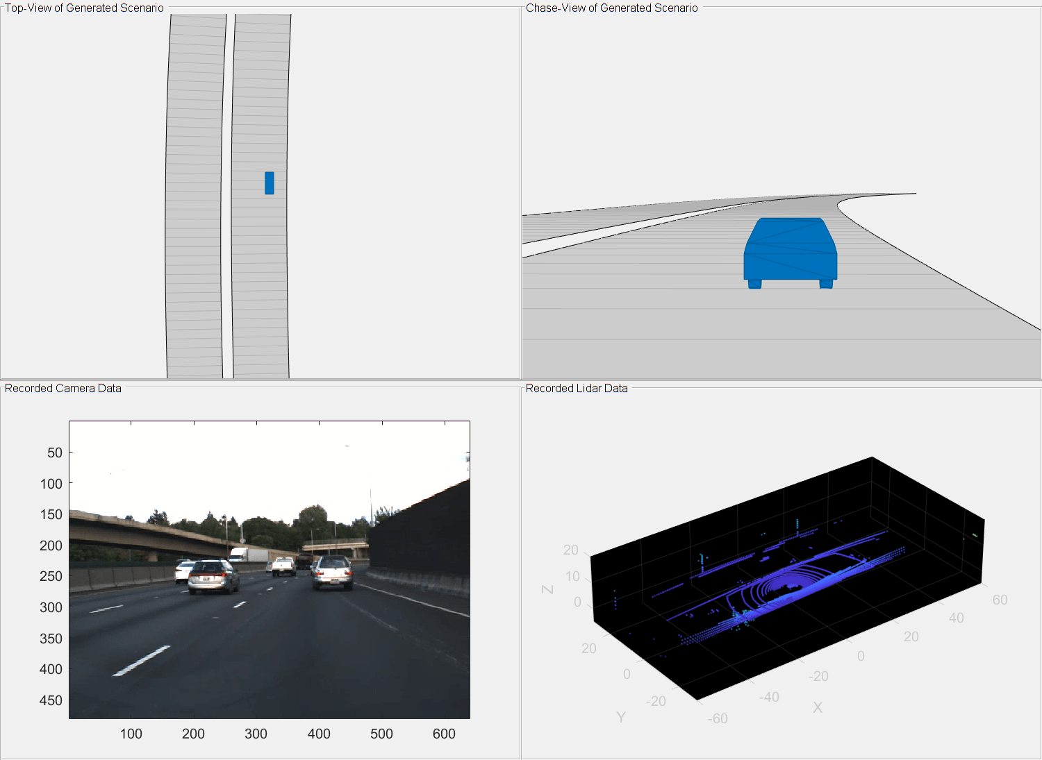
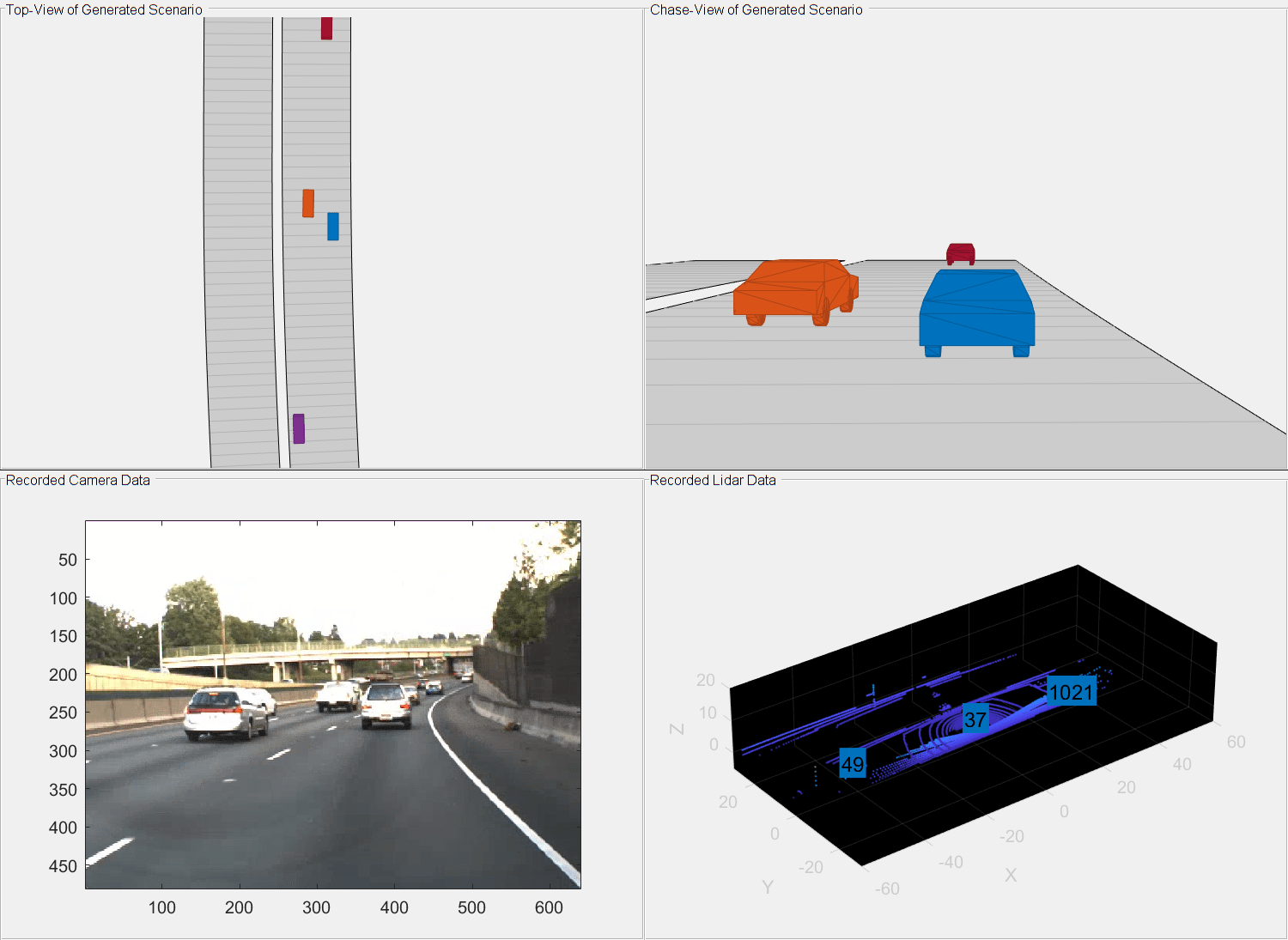
Display the top-view and chase-view plots of the generated scenario.
restart(scenario)
close all
fig = figure;
set(fig,Position=[40 40 1000 800]);
% Ego Top View
hPanel = uipanel(fig, ...
    Title="Top-View of Generated Scenario",Position=[0 0.5 0.5 0.5]);
hPlot = axes(hPanel);
chasePlot(egoVehicle,Parent=hPlot, ...
    ViewPitch=90,ViewHeight=120,ViewLocation=[0, 0]);

% Ego ChasePlot
hPanel2 = uipanel(fig, ...
    Title="Chase-View of Generated Scenario",Position=[0.5 0.5 0.5 0.5]);
hPlot2 = axes(hPanel2);
chasePlot(egoVehicle,Parent=hPlot2,Meshes='on');
Specify an axes for displaying the camera data.
% Image from camera
hPanel3 = uipanel(fig, ...
    Title="Recorded Camera Data",Position=[0 0 0.5 0.5]);
hPlot3 = axes(hPanel3);

% Initialize last used indices of the sensor
last.lidarIndex = 0;
last.cameraIndex = 0;
Plot the lidar point cloud data.
hPanel4 = uipanel(fig, ...
    Title ="Recorded Lidar Data",Position=[0.5 0 0.5 0.5]);
hPlot4 = axes(hPanel4);

% Initialize Display
xlimits = [-60 60];
ylimits = [-30 30];
zlimits = [-5 20];
player = pcplayer(xlimits,ylimits,zlimits,Parent=hPlot4);
Call the advance function in a loop to advance the simulation one time step at a time.
while advance(scenario)
    if last.cameraIndex + 1 <= count.camera && ...
            scenario.SimulationTime >= camera.relativeTime(last.cameraIndex+1)
        condition = true;
        while condition
            last.cameraIndex = last.cameraIndex + 1;
            condition = scenario.SimulationTime < ...
                camera.relativeTime(last.cameraIndex);
        end
        image(camera.img{last.cameraIndex,1},Parent=hPlot3);
    end
    %
    if last.lidarIndex + 1 <= count.lidar && ...
            scenario.SimulationTime >= lidar.relativeTime(last.lidarIndex + 1)
        condition = true;
        while condition
            last.lidarIndex = last.lidarIndex + 1;
            condition = scenario.SimulationTime < ...
                lidar.relativeTime(last.lidarIndex);
        end

        % Plot point cloud with bounding box and label
        ptCloud = lidar.ptCloud{last.lidarIndex,1};
        confirmedTracks = trackList.object{last.lidarIndex,1};
        view(player,ptCloud);
        % The helperParseTracks function returns position, dimension, and orientation of the 3-D bounding boxes.
        posIndex = [1 3 6];
        velocityIndex = [2 4 7];
        yawIndex = 8;
        dimIndex = [9 10 11];
        if ~isempty(confirmedTracks)
            [pos,dims,orients,labels] = helperParseTracks(confirmedTracks,posIndex,dimIndex,yawIndex);
            yaw = zeros(size(pos,1),3);
            yaw(:,3) = orients';
            bboxes = [pos,dims,yaw];
            showShape(cuboid=bboxes,Label=labels',Parent=hPlot4);
        end
    end
    pause(sim.sampleTime)
end
References
[1] Park, Seo-Wook, Kunal Patil, Will Wilson, Mark Corless, Gabriel Choi, and Paul Adam. “Creating Driving Scenarios from Recorded Vehicle Data for Validating Lane Centering System in Highway Traffic,” 2020-01–0718, 2020. https://doi.org/10.4271/2020-01-0718.
See Also
road | roadNetwork | vehicle | actor | trajectory | drivingScenario | advance | restart | plot