gatherLabelData
Gather synchronized label data from ground truth
Syntax
Description
labelData = gatherLabelData(gTruth,signalNames,labelTypes)gTruth. The function returns label data for the signals specified by
signalNames and the label types specified by
labelTypes.
[
additionally returns the signal timestamps associated with the gathered label data, using
the arguments from the previous syntax.labelData,timestamps] = gatherLabelData(___)
Use timestamps with the writeFrames
function to write the associated signal frames from the
groundTruthMultisignal objects to disk. Use these frames and the
associated labels as training data for machine learning or deep learning models.
[___] = gatherLabelData(___,
specifies options using one or more name-value arguments in addition to any combination of
arguments from previous syntaxes. For example, Name=Value)Verbose=True enables
display to the workspace environment.
Examples
Gather label data for a video signal and a lidar point cloud sequence signal from a groundTruthMultisignal object. Write the signal frames associated with that label data to disk and visualize the frames.
Add the point cloud sequence folder path to the MATLAB® search path. The video is already on the MATLAB search path.
pcSeqDir = fullfile(toolboxdir('driving'),'core','drivingdata', ...
    'lidarSequence');
addpath(pcSeqDir);
Load a groundTruthMultisignal object that contains label data for the video and the lidar point cloud sequence.
data = load('MultisignalGTruth.mat');
gTruth = data.gTruth;
Specify the signals from which to gather label data.
signalNames = ["video_01_city_c2s_fcw_10s" "lidarSequence"];
The video contains rectangle labels, whereas the lidar point cloud sequence contains cuboid labels. Gather the rectangle labels from the video and the cuboid labels from the lidar point cloud sequence.
labelTypes = [labelType.Rectangle labelType.Cuboid];
[labelData,timestamps] = gatherLabelData(gTruth,signalNames,labelTypes);
Display the first eight rows of label data from the two signals. Both signals contain data for the Car label. In the video, the Car label is drawn as a rectangle bounding box. In the lidar point cloud sequence, the Car label is drawn as a cuboid bounding box.
videoLabelSample = head(labelData{1})
lidarLabelSample = head(labelData{2})
videoLabelSample =

  table

           Car
    _________________

    {[299 213 42 33]}


lidarLabelSample =

  table

                            Car
    ____________________________________________________

    {[17.7444 6.7386 3.3291 3.6109 3.2214 3.5583 0 0 0]}
Write signal frames associated with the gathered label data to temporary folder locations, with one folder per signal. Use the timestamps returned by the gatherLabelData function to indicate which signal frames to write.
outputFolder = fullfile(tempdir,["videoFrames" "lidarFrames"]);
fileNames = writeFrames(gTruth,signalNames,outputFolder,timestamps);
Writing 2 frames from the following signals:

* video_01_city_c2s_fcw_10s
* lidarSequence
Load the written video signal frames by using an imageDatastore object. Load the associated rectangle label data by using a boxLabelDatastore object.
imds = imageDatastore(fileNames{1});
blds = boxLabelDatastore(labelData{1});
Load the written lidar signal frames by using a fileDatastore object. Load the associated cuboid label data by using a boxLabelDatastore object.
fds = fileDatastore(fileNames{2},'ReadFcn',@pcread);
clds = boxLabelDatastore(labelData{2});
Visualize the written video frames by using a vision.VideoPlayer object. Visualize the written lidar frames by using a pcplayer object.
videoPlayer = vision.VideoPlayer;

ptCloud = preview(fds);
ptCloudPlayer = pcplayer(ptCloud.XLimits,ptCloud.YLimits,ptCloud.ZLimits);

while hasdata(imds)
    % Read video and lidar frames.
    I = read(imds);
    ptCloud = read(fds);

    % Visualize video and lidar frames.
    videoPlayer(I);
    view(ptCloudPlayer,ptCloud);
end


Remove the path to the point cloud sequence folder.
rmpath(pcSeqDir);
Input Arguments
Multisignal ground truth data, specified as a groundTruthMultisignal object or vector of
groundTruthMultisignal objects.
Each groundTruthMultisignal object in gTruth
must include all the signals specified in the signalNames
input.
In addition, each object must include at least one marked label per gathered label
definition. Suppose gTruth is a
groundTruthMultisignal object containing label data for a single
video signal named video_front_camera. The object contains marked
rectangle region of interest (ROI) labels for the car label
definition but not for the truck label definition. If you use this
syntax to gather labels of type Rectangle from this object, then the
gatherLabelData function returns an
error.
labelData = gatherLabelData(gTruth,"video_front_camera",labelType.Rectangle);Names of the signals from which to gather label data, specified as a character
vector, string scalar, cell array of character vectors, or string vector. The signal
names must be valid signal names stored in the input multisignal ground truth data,
gTruth.
To obtain the signal names from a groundTruthMultisignal object,
use this syntax, where gTruth is the variable name of the
object:
gTruth.DataSource.SignalName
Example: 'video_01_city_c2s_fcw_10s'
Example: "video_01_city_c2s_fcw_10s"
Example: {'video_01_city_c2s_fcw_10s','lidarSequence'}
Example: ["video_01_city_c2s_fcw_10s"
"lidarSequence"]
Label types from which to gather label data, specified as a labelType enumeration scalar, labelType enumeration vector,
or a cell array of labelType enumeration scalars and vectors. The
gatherLabelData function gathers label data for each signal
specified by input signalNames and each
groundTruthMultisignal object specified by input
gTruth. The number of elements in labelTypes
must match the number of signals in signalNames.
Gather Label Data for Single Label Type per Signal
To gather label data for a single label type per signal, specify
labelTypes as a labelType enumeration scalar
or vector. Across all groundTruthMultisignal objects in
gTruth, the gatherLabelData function
gathers labelTypes(n) label data from
signalName(n), where n is the index of the
label type and the corresponding signal name whose label data is to be gathered. Each
returned table in the output labelData cell array contains data
for only one label type per signal.
In this code sample, the gatherLabelData function gathers
labels of type Rectangle from a video signal named
video_front_camera. The function also gathers labels of type
Cuboid from a lidar point cloud sequence signal stored in a
folder named lidarData. The gTruth input
contains the groundTruthMultisignal objects from which this data is
to be
gathered.
labelData = gatherLabelData(gTruth, ...
                            ["video_front_camera","lidarData"], ...
                            [labelType.Rectangle,labelType.Cuboid];
To gather label data for a single label type from separate signals, you must
repeat the label type for each signal. In this code sample, the
gatherLabelData function gathers labels of type
Rectangle from the video_left_camera and
video_right_camera video
signals.
labelData = gatherLabelData(gTruth, ...
                            ["video_left_camera","video_right_camera"], ...
                            [labelType.Rectangle,labelType.Rectangle];
Gather Label Data for Multiple Label Types per Signal
To gather label data for multiple label types per signal, specify
labelTypes as a cell array of labelType
enumeration scalars and vectors. Across all groundTruthMultisignal
objects in gTruth, the gatherLabelData
function gathers labelTypes{n} label data from
signalName(n), where n is the index of the
label types and the corresponding signal name whose label data is to be gathered. The
function groups the data for these label types into one table per signal per
groundTruthMultisignal object.
In this code sample, the gatherLabelData function gathers
labels of type Rectangle and Line from the
video_front_camera video signal. The function also gathers labels
of type Cuboid from a lidar point cloud sequence signal stored in a
folder named lidarData. The gTruth input
contains the groundTruthMultisignal objects from which this data is
to be
gathered.
labelData = gatherLabelData(gTruth, ...
                            ["video_front_camera", ...
                             "lidarData"], ...
                            {[labelType.Rectangle labelType.Line], ...
                             labelType.Cuboid};
Valid Enumeration Types
You can specify one or more of these enumeration types.
labelType.Rectangle— Rectangle ROI labelslabelType.RotatedRectangle— Rotated Rectangle ROI labelslabelType.Cuboid— Cuboid ROI labels (point clouds)labelType.ProjectedCuboid— Projected cuboid ROI labels (images and video data)labelType.Line— Line ROI labelslabelType.PixelLabel— Pixel ROI labelslabelType.Polygon— Pixel ROI labelslabelType.Scene— Scene labels
To gather label data for scenes, you must specify labelTypes
as the labelType.Scene enumeration scalar. You cannot specify any
other label types with labelType.Scene.
Name-Value Arguments
Specify optional pairs of arguments as
Name1=Value1,...,NameN=ValueN, where Name is
the argument name and Value is the corresponding value.
Name-value arguments must appear after other arguments, but the order of the
pairs does not matter.
Example: (SamplingFactor=5) sets the subsampling
factor to 5 to drop every fifth frame.
Sample factor used to subsample label data, specified as a positive integer. A
sample factor of K includes every Kth signal
frame. Increase the sample factor to drop redundant frames from signals with high
sample rates, such as videos. To set the SamplingFactor with
projected cuboid data, you must specify the LabelData name-value
argument to labelType.ProjectedCuboid.
Use sampled data to reduce repeated data, such as a sequence of images with the same scene and labels. It can also help in reducing training time.
Group columns from label data, specified as "LabelName" or
"LabelType".
"LabelName"— Groups the label data into columns by label definitions."LabelType"— Groups the label data into columns by label type. You can use this option to gather label data while retaining the region-of-interest (ROI) stacking order determined by the label type.
Logical to indicate if attribute and sublabel data is returned in label data
output, specified as a logical false (0) or
true (1). A value of false
indicates that only the position values that correspond to ROIs are collected. A value
of true indicates that each table in LabelData
contain structs that contain the position, attributes, and sublabels associated with
each label.
Output Arguments
Label data, returned as an M-by-N cell array
of tables, where:
Mis the number ofgroundTruthMultisignalobjects ingTruth.When
labelTypescontains ROIlabelTypeenumerations,Nis the number of signals insignalNamesand the number of elements inlabelTypes. In this case,labelData{m,n}contains a table of label data for thenth signal ofsignalNamesthat is in themthgroundTruthMultisignalobject ofgTruth. The table contains label data for only the label types in thenth position oflabelTypes.When
labelTypescontains only thelabelType.Sceneenumeration,Nis equal to1. In this case,labelData{m}contains a table of scene label data across all signals in themthgroundTruthMultisignalobject ofgTruth.
For a given label data table, tbl, the table is of size
T-by-L, where:
Tis the number of timestamps in the signal for which label data exists.Lis the number of label definitions that are of the label types gathered for that signal.tbl(t,l)contains the label data gathered for thelth label at thetth timestamp.
If one of the signals has no label data at a timestamp, then the corresponding label data table does not include a row for that timestamp.
For each cell in the table, the format of the returned label data depends on the type of label.
| Label Type | Storage Format for Labels at Each Timestamp |
|---|---|
labelType.Rectangle |
|
labelType.RotatedRectangle |
For one or more rotated rectangles, specify in spatial coordinates as an M-by-5 numeric matrix, where each row specifies a rotated rectangle of the form [xctr yctr w h yaw].
|
|
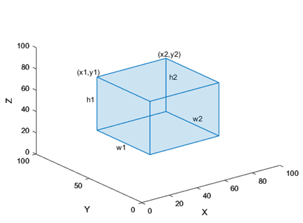
The figure shows how these values determine the position of a cuboid.
|
|
The figure shows how these values determine the position of a cuboid.
|
labelType.Line |
|
labelType.PixelLabel | Label data for all pixel label definitions is stored in a
single M-by-1 |
labelType.Polygon |
|
labelType.Scene | Logical 1 (true) if the scene label
is applied. Otherwise logical 0
(false) |
Label Data Format
Consider a cell array of label data gathered by using the
gatherLabelData function. The function gathers labels from
three groundTruthMultisignal objects with variable names
gTruth1, gTruth2, and
gTruth3.
For a video signal named
video_front_camera, the function gathers labels of typeRectangleandLine.For a lidar point cloud sequence signal stored in a folder named
lidarData, the function gathers labels of typeCuboid.
This code shows the call to the gatherLabelData
function.
labelData = gatherLabelData([gTruth1 gTruth2 gTruth3], ...
                            ["video_front_camera", ...
                             "lidarData"], ...
                            {[labelType.Rectangle labelType.Line], ...
                             labelType.Cuboid};
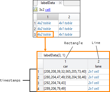
labelData output is a 3-by-2 cell array of tables. Each row of
the cell array contains label data for one of the
groundTruthMultisignal objects. The first column contains the label
data for the video signal, video_front_camera. The second column
contains the label data for the point cloud sequence signal,
lidarData. This figure shows the labelData
cell array.

This figure shows the label data table for the video signal in the third
groundTruthMultisignal object. The
gatherLabelData function gathered data for a
Rectangle label named car and a
Line label named lane. The table contains
label data at four timestamps in the signal.

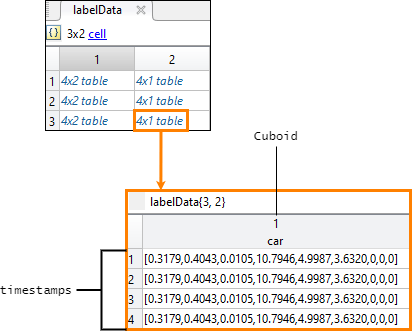
This figure shows the label data table for the lidar signal in the third
groundTruthMultisignal object. The
gatherLabelData function gathered data for a
Cuboid label, also named car. The
car label appears in both signal types because it is marked as a
Rectangle label for video signals and a Cuboid
label for lidar signals. The table contains label data at four timestamps in the
signal.

Signal timestamps, returned as an M-by-N cell
array of duration vectors, where:
Mis the number ofgroundTruthMultisignalobjects ingTruth.Nis the number of signals insignalNames.labelData{m,n}contains the timestamps for thenth signal ofsignalNamesthat is in themthgroundTruthMultisignalobject ofgTruth.
If you gather label data from multiple signals, the signal timestamps are
synchronized to the timestamps of the first signal specified by
signalNames.
Version History
Introduced in R2020a
See Also
MATLAB Command
You clicked a link that corresponds to this MATLAB command:
Run the command by entering it in the MATLAB Command Window. Web browsers do not support MATLAB commands.
웹사이트 선택
번역된 콘텐츠를 보고 지역별 이벤트와 혜택을 살펴보려면 웹사이트를 선택하십시오. 현재 계신 지역에 따라 다음 웹사이트를 권장합니다:
또한 다음 목록에서 웹사이트를 선택하실 수도 있습니다.
사이트 성능 최적화 방법
최고의 사이트 성능을 위해 중국 사이트(중국어 또는 영어)를 선택하십시오. 현재 계신 지역에서는 다른 국가의 MathWorks 사이트 방문이 최적화되지 않았습니다.
미주
- América Latina (Español)
- Canada (English)
- United States (English)
유럽
- Belgium (English)
- Denmark (English)
- Deutschland (Deutsch)
- España (Español)
- Finland (English)
- France (Français)
- Ireland (English)
- Italia (Italiano)
- Luxembourg (English)
- Netherlands (English)
- Norway (English)
- Österreich (Deutsch)
- Portugal (English)
- Sweden (English)
- Switzerland
- United Kingdom (English)

