결과: 44개
An Image Georectification and Feature Tracking toolbox

Robust reader of ENVI header files.
Explore USGS Landsat8 data hosted by Amazon Web Services
Forest remote sensing tools for Matlab

LiDAR point cloud ground filtering / segmentation (bare earth extraction) method based on cloth simulation.

% AggregateIma resize an image to a smaller one
An application of remote sensing with infrared imaging in greenhouse systems has been developed.

Reads the information from MTL text file, which is provided with LANDSAT 7 ETM+ data.
convertion of image to black and white image using slicing image without background.
This set of functions builds the physical model of SPOT 6/7 stereo imagery data and can be used to extract a DEM from such data.
Can be used in HyperSpectral Image Remote Sensing. Produces a matching/Score matrix.
Reads field-value pairs from the MTL text file, and returns a structure with the scene metadata.
Formulation for the estimation of the soil moisture (SM) in the root zone based on the measured value of SM at the surface

Generate KML file to show modis tile pixel for a specific point

Calculate camera orientation from the horizon to stabilize and rectify images from ships.
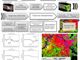
BITE derives disturbance maps from satellite image stacks
Read and write point clouds into Matlab using LAStools library

Automatic detection of residential buildings using LIDAR data and multispectral imagery
버전 1.0.0.0
Mohammad AwrangjebPresents two automatic building detection techniques using multispectral imagery and LIDAR data.
Reads in ROI files from ENVI saved in ASCII format

Image Processing
An atmospheric tomography toy model setup over a 3-D area of interest.

HIRBERT: Hyperspectral Imaging of River Bathymetry using an Ensemble of Regression Trees
Toolbox for River Velocimetry using Images from Aircraft: TRiVIA
Three simple functions for resampling, rotating and scaling an image

Image aggregation of the SAR image of Sentinel 1A.

critFlowQ: Infer river discharge from remotely sensed data based on critical flow theory

Demonstrates how to download NASA Earthshots data with RESTful get.
Simulate Propagation in 2-D

Validation Toolbox (Performance Metrics for Remote Sensing Data and Climate Model Simulations)
버전 1.1.0.0
HRLPerformance Metrics for Remote Sensing Data and Climate Model Simulations

This GUI is used to compute the spectral sensor foot print.
generate KML file of AMRSs EASE 25km by 25km grids for showing in Google earth.

Determines the amount of pixel loss by void stripping on ETM+ images by SLC-off.
Transform planar local coordinates to latitude longitude coordinates
Resample spectra for the reflectance of various common remote sensing devices
The Optical River Bathymetry Toolkit is an application to facilitate mapping water depth in river channels from passive optical image data.

SAS: Software Application for SMASH (Spectral Mixture Analysis for Surveillance of Harmful Algal Blooms)

InQUIRI: Inferring Q (discharge) from UHJ’s (undular hydraulic jumps) Identified in River Images

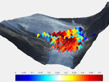
Tall wind profile validation of ERA5, NORA3 and NEWA, using lidar observations

object detection methods for remote sensing images based on local features
Read multiple layers of TIFF images.
code to read multiple QuikSCAT L3 data in extension *. hdf
A quick how-to example file.

Using a training image set for finding similar invariant color features in input images

sundial: Infer image acquisition time from shadow orientation
또한 다음 목록에서 웹사이트를 선택하실 수도 있습니다.
미주
- América Latina (Español)
- Canada (English)
- United States (English)
유럽
- Belgium (English)
- Denmark (English)
- Deutschland (Deutsch)
- España (Español)
- Finland (English)
- France (Français)
- Ireland (English)
- Italia (Italiano)
- Luxembourg (English)
- Netherlands (English)
- Norway (English)
- Österreich (Deutsch)
- Portugal (English)
- Sweden (English)
- Switzerland
- United Kingdom(English)
아시아 태평양
- Australia (English)
- India (English)
- New Zealand (English)
- 中国
- 日本Japanese (日本語)
- 한국Korean (한국어)