uavCoveragePlanner
Description
The uavCoveragePlanner object plans an optimal path that a UAV can
follow to cover an region of interest with a sensor such as a camera for precision agriculture
and image mapping applications. The object finds the optimal path by finding a sweep angle
that minimizes the number of turns in each polygon and uses one of two specified solver
algorithms to optimize the connecting path between regions.
Creation
Syntax
Description
planner = uavCoveragePlanner(
creates a coverage planner coverageSpace)planner from a coverage space
coverageSpace and sets the CoverageSpace
property.
planner = uavCoveragePlanner(
sets properties using one or more name-value arguments.coverageSpace,Name=Value)
Properties
Object Functions
plan | Plan 3D survey path through coverage area |
exportWaypointsPlan | Export waypoints to file |
Examples
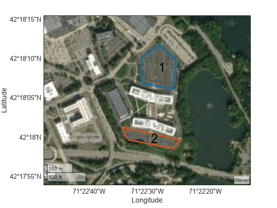
This example shows how to plan a coverage path that surveys the parking lots of the MathWorks Lakeside campus.
Get the geodetic coordinates for the MathWorks Lakeside campus, then create the limits for our map.
mwLS = [42.3013 -71.375 0];
latlim = [mwLS(1)-0.003 mwLS(1)+0.003];
lonlim = [mwLS(2)-0.003 mwLS(2)+0.003];
Create a figure containing the map with the longitude and latitude limits.
fig = figure;
g = geoaxes(fig,Basemap="satellite");
geolimits(latlim,lonlim)
Get the outline of the first parking lot in longitude and latitude coordinates. Then create the polygon by concatenating them.
pl1lat = [42.3028 42.30325 42.3027 42.3017 42.3019]';
pl1lon = [-71.37527 -71.37442 -71.3736 -71.37378 -71.375234]';
pl1Poly = [pl1lat pl1lon];
Repeat the process for the second parking lot.
pl2lat = [42.30035 42.2999 42.2996 42.2999]';
pl2lon = [-71.3762 -71.3734 -71.37376 -71.37589]';
pl2poly = [pl2lat pl2lon];
Create the coverage space with both polygons, and specify these properties:
Waypoints coordinates format: Geodetic
Reference location: MathWorks Lakeside campus location
Reference height: 25 meters
Width of sensor footprint: 20 meters
cs = uavCoverageSpace(Polygons={pl1Poly,pl2poly},UseLocalCoordinates=false,...
    ReferenceLocation=mwLS,ReferenceHeight=25,UnitWidth=20);
Show the coverage space on the map.
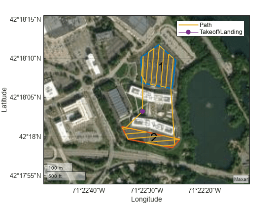
show(cs,Parent=g);
Set the sweep angle for polygons 1 and 2 to 85 and 5 degrees, respectively, to have paths that are parallel to the roads in the parking lots. Then create the coverage planner for that coverage space with the exhaustive solver algorithm.
setCoveragePattern(cs,1,SweepAngle=85)
setCoveragePattern(cs,2,SweepAngle=5)
cp = uavCoveragePlanner(cs,Solver="Exhaustive");
Set the takeoff position to a location in the courtyard, then plan the coverage path.
takeoff = [42.30089 -71.3752, 0];
[wp,soln] = plan(cp,takeoff);
hold on
geoplot(wp(:,1),wp(:,2),LineWidth=1.5);
geoplot(takeoff(1),takeoff(2),MarkerSize=25,Marker=".")
legend("","","Path","Takeoff/Landing")
hold off
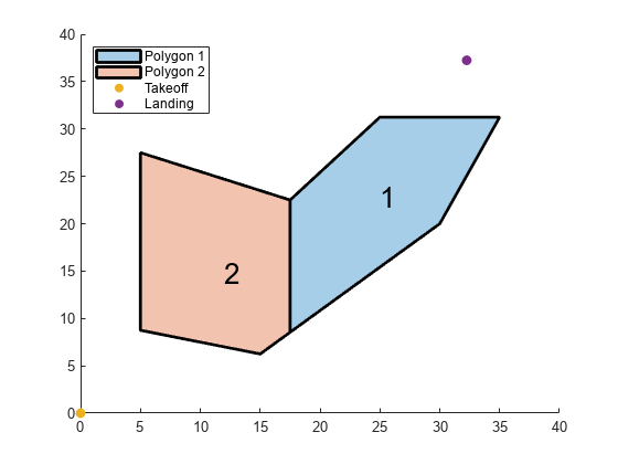
This example shows how to plan a coverage path for a region in local coordinates and compares the results of using the exhaustive solver with the results of using the minimum traversal solver.
Define the vertices for a coverage space.
area = [5 8.75; 5 27.5; 17.5 22.5; 25 31.25; 35 31.25; 30 20; 15 6.25];
Because vertices define a concave polygon and the coverage planner requires convex polygons, decompose the polygon into convex polygons. Then create a coverage space with the polygons from decomposition.
polygons = coverageDecomposition(area);
cs = uavCoverageSpace(Polygons=polygons);
Define the takeoff and landing positions at [0 0 0] and [32.25 37.25 0], respectively. Then show the coverage space and plot the takeoff and landing positions.
takeoff = [0 0 0];
landing = [32.25 37.25 0];
show(cs);
exampleHelperPlotTakeoffLandingLegend(takeoff,landing)
Create a coverage planner with the exhaustive solver algorithm and another coverage planner with a minimum traversal solver algorithm. Because Polygon 2 is closer to the takeoff position, set the visiting sequence of the solver parameters such that we traverse Polygon 2 first.
cpeExh = uavCoveragePlanner(cs,Solver="Exhaustive");
cpMin = uavCoveragePlanner(cs,Solver="MinTraversal");
cpeExh.SolverParameters.VisitingSequence = [2 1];
cpMin.SolverParameters.VisitingSequence = [2 1];
Plan with both solver algorithms using the same takeoff and landing positions.
[wptsExh,solnExh] = plan(cpeExh,takeoff,landing);
[wptsMin,solnMin] = plan(cpMin,takeoff,landing);
Show the planned path for both the exhaustive and the minimum traversal algorithms.
figure
show(cs);
title("Exhaustive Solver Algorithm")
exampleHelperPlotTakeoffLandingLegend(takeoff,landing,wptsExh)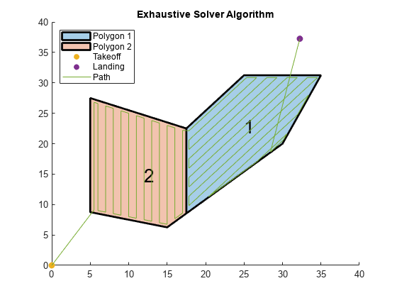
figure
show(cs);
title("Minimum Traversal Solver Algorithm")
exampleHelperPlotTakeoffLandingLegend(takeoff,landing,wptsMin)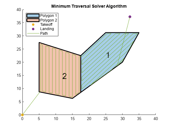
Export the waypoints from the minimum traversal solver to a .waypoints file with the reference frame set to north-east-down.
exportWaypointsPlan(cpMin,solnMin,"coveragepath.waypoints",ReferenceFrame="NED")
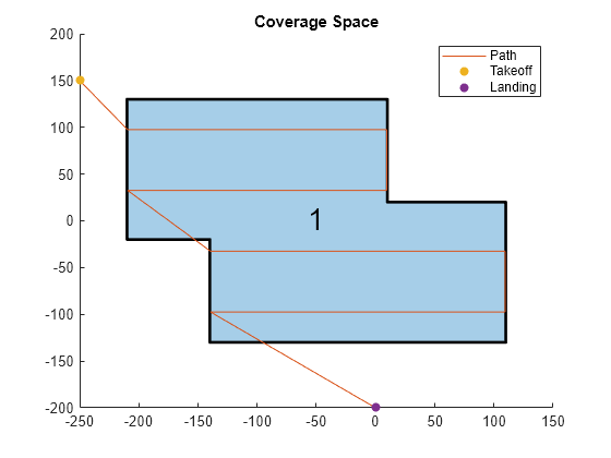
Initialize the settings to use for the coverage planner, coverage space, and mission. Set a coverage width to 65 meters, the region as polygon vertices, takeoff and landing locations, the UAV elevation during flight to 150 meters, and a geocenter.
coverageWidth = 65;
region = [-210 130; 10 130; 10 20; 110 20;
          110 -130; -140 -130; -140 -20; -210 -20];
takeoff = [-250 150 0];
landing = [0 -200 0];
uavElevation = 150;
geocenter = [-45 71 0];
Create the coverage space with those UAV coverage space settings.
cs = uavCoverageSpace(Polygons=region, ...
                      UnitWidth=coverageWidth, ...
                      ReferenceHeight=uavElevation, ...
                      ReferenceLocation=geocenter);

cs.show;
title("Coverage Space")

Create a coverage planner for the coverage space and plan the coverage path with the specified takeoff and landing locations.
cp = uavCoveragePlanner(cs);
[waypoints,solnInfo] = cp.plan(takeoff,landing);
Plot the waypoints, and the takeoff and landing locations on the coverage space.
hold on
plot(waypoints(:,1),waypoints(:,2))
scatter(takeoff(1),takeoff(2),"filled")
scatter(landing(1),landing(2),"filled")
legend("","Path","Takeoff","Landing")
hold off
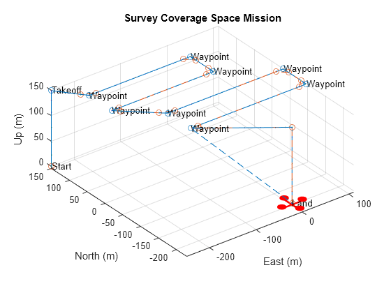
Export the waypoints to a waypoints file and create a UAV mission from that file with a speed of 10 meters per second and an initial yaw of 90 degrees.
exportWaypointsPlan(cp,solnInfo,"customCoverage.waypoints");
mission = uavMission(PlanFile="customCoverage.waypoints",Speed=10,InitialYaw=90);
Use the exampleHelperSimulateUAVMission helper function to visualize the UAV mission with a simulation time of 60 seconds.
exampleHelperSimulateUAVMission(mission,geocenter)
References
[1] Torres, Marina, David A. Pelta, José L. Verdegay, and Juan C. Torres. “Coverage Path Planning with Unmanned Aerial Vehicles for 3D Terrain Reconstruction.” Expert Systems with Applications 55 (August 2016): 441–51. https://doi.org/10.1016/j.eswa.2016.02.007.
[2] Li, Yan, Hai Chen, Meng Joo Er, and Xinmin Wang. “Coverage Path Planning for UAVs Based on Enhanced Exact Cellular Decomposition Method.” Mechatronics 21, no. 5 (August 2011): 876–85. https://doi.org/10.1016/j.mechatronics.2010.10.009.