주요 콘텐츠

tropopl

R2026b

Atmospheric gas absorption loss

Description

tropopl returns the frequency-dependent loss caused by atmospheric gas absorption that occurs along the propagated path between a sensor and target within a layered, refracting atmosphere. Refraction loss due to tropospheric lensing is optionally returned. Radar frequency signals refract due to vertical gradients in the atmospheric refractive index, which bends the propagation path downward. See Layered Atmosphere Model for more information.

Lgas = tropopl(sr,freq,ht,el) returns the loss due to atmospheric gas absorption along the propagated path as a function of straight-line slant range distance sr, frequency freq, height ht, and elevation angle el using the International Telecommunication Union (ITU) standard layered atmospheric model.

Lgas = tropopl(___,Name=Value) specifies additional inputs using name-value arguments. For example, you can specify the reference latitude model and water vapor density.

example

[Lgas,Llens] = tropopl(___) also returns the corresponding refraction loss due to lensing for positive elevation angles. The strong variation in refractivity versus altitude in the troposphere causes the atmosphere to act like a lens with loss independent of frequency (see Refraction Loss Due to Lensing).

Examples

collapse all

Calculate the attenuation versus range for a frequency of 100 GHz with an elevation of 5 degrees using the mid-latitude, winter atmospheric model.

R  = (10:100)*1e3;      % m
f  = 100e9;             % Hz
ht = 0;                 % m
el = 5;                 % deg
Lgas = tropopl(R,f,ht,el,'LatitudeModel','Mid','Season','Winter');

Plot the results.

semilogy(R.*1e-3,Lgas);
xlabel('Range (km)');
ylabel('Attenuation (dB)');
title('Attenuation for Mid-Latitude, Winter Atmosphere');
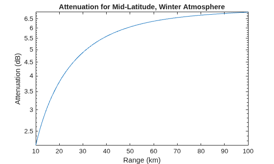
Figure contains an axes object. The axes object with title Attenuation for Mid-Latitude, Winter Atmosphere, xlabel Range (km), ylabel Attenuation (dB) contains an object of type line.

Input Arguments

collapse all

Slant range, or straight-line geometric distance between sensor and target, specified as a positive scalar or M-length positive vector. Units are in meters (m).

Data Types: single | double

Radar frequency, specified as a positive scalar or N-length positive vector. Units are in hertz (Hz).

Data Types: single | double

Height or altitude of radar relative to mean sea level (MSL), specified as a nonnegative scalar from 0 to 100000 m. Units are in meters (m).

Example: 2000

Data Types: single | double

Elevation angle of the sensor, specified as a scalar or M-length vector when sr is also an M-length vector. The elevation angle is the initial elevation angle of the ray leaving the sensor. A negative elevation angle points downwards toward the ground (see Radar Coordinate Systems and Frames). The optional refraction loss due to lensing is set to zero for negative elevation angles. Units are in degrees (deg).

Example: 10

Data Types: single | double

Name-Value Arguments

collapse all

Specify optional pairs of arguments as Name1=Value1,...,NameN=ValueN, where Name is the argument name and Value is the corresponding value. Name-value arguments must appear after other arguments, but the order of the pairs does not matter.

Before R2021a, use commas to separate each name and value, and enclose Name in quotes.

Example: Lgas = tropopl(100,1e9,10,10,LatitudeModel="Mid",Season="Winter")

Reference latitude model, specified as one of these:

ModelDescription
"Standard"(default)

This model is the mean annual global reference atmosphere (MAGRA) that reflects the mean annual temperature and pressure averaged across the world.

"Low"

This model is for low latitudes less than 22 degrees, where there is little seasonal variation.

"Mid"

This model is for mid latitudes between 22 and 45 degrees with seasonal profiles available for "Summer" and "Winter", which can be specified using the Season name-value argument.

"High"

This model is for high latitudes greater than 45 degrees with seasonal profiles available for "Summer" and "Winter", which can be specified using the Season name-value argument.

Data Types: string | char

Season for the "Mid" and "High" LatitudeModel, specified as "Summer" or "Winter". Other LatitudeModel selections ignore this input. The default value is "Summer".

Data Types: string | char

Ground-level water vapor density, specified as a positive scalar. This name-value argument is applicable only for the default "Standard" LatitudeModel MAGRA model. The default value is 7.5. Units are in g/m3.

Data Types: double

Scale height or altitude above mean sea level (MSL), specified as a positive scalar. This name-value argument is applicable only for the default "Standard" LatitudeModel MAGRA model. The default value is 2e3. For dry atmospheric conditions, set scale height to 6e3. Units are in meters (m).

Data Types: double

Custom atmospheric measurements for the calculation of attenuation due to gas, specified as an N-by-4 matrix, where N corresponds to the number of altitude measurements. N must be greater than or equal to 2. The first column is the atmospheric temperature in kelvins, the second column is the atmospheric pressure in hPa, the third column is the water vapor density in g/m3, and the fourth column is the MSL altitude of the measurements in meters. When you use a custom model, all other name-value arguments are ignored.

Note

The Layered Atmosphere Model assumes geometrical optics conditions, as a result anomalous propagation like ducting and sub-refraction cannot be present in provided measurements. If atmospheric measurements evidencing ducting and sub-refraction are provided, this function throws an error.

Note

The atmositu, gaspl, and tropopl functions use different units for pressure and temperature.

Pressure and Temperature Units

FunctionPressure UnitsTemperature Units
atmosituhectoPascals (hPa)kelvin (K)
tropoplhectoPascals (hPa)kelvin (K)
gasplPascals (Pa)Celsius (C)

One hPa equals 100 Pa and K = C + 273.15. Use caution when combining the use of these three functions.

Data Types: single | double

Output Arguments

collapse all

Path loss due to tropospheric refraction, specified as an M-by-N real matrix. M and N are defined by the slant range, R, and frequency, F, arguments, respectively. Units are in decibels (dB).

One-way refraction loss due to tropospheric lensing, returned as an M-by-N matrix. The frequency-independent refraction loss due to atmospheric lensing is determined using the lenspl function. A value of 0 is returned when el is negative. M and N are defined by the size of the slant range sr and frequency freq arguments, respectively. The lensing loss can be significant for small elevation angles and long ranges. Lensing loss is not due to a dissipation of energy and therefore does not contribute to the system noise temperature. Units are in decibels (dB).

Data Types: double

More About

collapse all

References

[1] International Telecommunication Union (ITU). "Reference Atmospheres". Recommendation ITU-R P.835-7, P Series, Radiowave Propagation (Aug. 2024).

[2] International Telecommunication Union (ITU). "Attenuation by Atmospheric Gases and Related Effects". Recommendation ITU-R P.676-12, P Series, Radiowave Propagation (Aug 2019).

[3] International Telecommunication Union (ITU). “The Radio Refractive Index: Its Formula and Refractivity Data.” Recommendation ITU-R P.453-11, P Series, Radiowave Propagation, July 2015.

Extended Capabilities

expand all

C/C++ Code Generation
Generate C and C++ code using MATLAB® Coder™.

Version History

Introduced in R2021a