height
Description
hgt = height(surface,pt)hgt of the point pt on the
surface. This syntax applies when the surface is a LandSurface,
SeaSurface, or
CustomSurface
object.
hgt = height(surface,pt,t)hgt of the point pt on the
surface at the time t. This syntax only applies
when the surface is a SeaSurface
object.
Examples
Create a square sea surface area using the seaSurface object. Assume a moderate sea state with a wind speed of about 10 m/s, a fetch of 250 km and a length of 1.0 km. Add an Elfouhaily spectrum to the sea surface. Use the height function to determine the heights of 2 points on the map.
Create a radar scenario.
scene = radarScenario(IsEarthCentered = false);
rng('default')
Add a sea surface to the scene with an Elfouhaily spectrum.
spec = seaSpectrum(Resolution = 20);
srf = seaSurface(scene,Boundary = [-500 500; -500 500], ...
    WindSpeed = 10,Fetch = 250000,SpectralModel = spec);
Find the height at two points.
P1 = [0;0];
P2 = [30;-70];
H = height(srf,[P1 P2])
H = 1×2

   -0.9394   -0.2682
Display the sea surface properties in the surface manager.
mgr = scene.SurfaceManager
mgr =
  SurfaceManager with properties:

    EnableMultipath: 0
       UseOcclusion: 1
           Surfaces: [1×1 radar.scenario.SeaSurface]
mgr.Surfaces
ans =
  SeaSurface with properties:

                WindSpeed: 10
            WindDirection: 0
                    Fetch: 250000
            SpectralModel: [1×1 seaSpectrum]
        RadarReflectivity: [1×1 surfaceReflectivitySea]
    ReflectionCoefficient: [1×1 radar.scenario.SurfaceReflectionCoefficient]
          ReflectivityMap: 1
          ReferenceHeight: 0
                 Boundary: [2×2 double]
Create a radar scenario. Add a 400-by-400 m area to the scenario with two simulated hills. Find the height of two points.
scene = radarScenario('IsEarthCentered',false);
bnds = [-200 200; -200, 200];
x = -200:200;
y = -200:200;
[X,Y] = meshgrid(x,y);
htmap = 20*exp(-X.^2/2000 - Y.^2/2000) + 10*exp(-(X-70).^2/2000 - (Y+100).^2/2000);
surf(X,Y,htmap)
shading interp
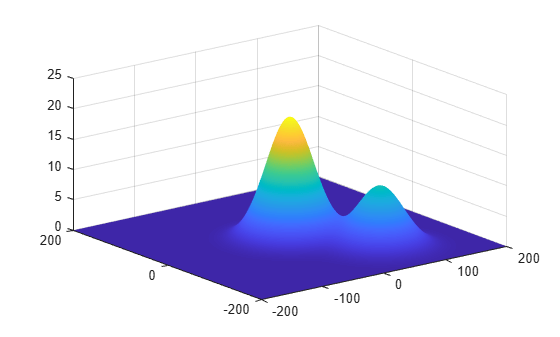
Find the height of the surface at two points.
P1 = [0.0; 0.0]; % Point 1
P2 = [28.0; -40.0];  % Point 2
srf = landSurface(scene,'Terrain',htmap,'Boundary',bnds)
srf =
  LandSurface with properties:

        RadarReflectivity: [1×1 surfaceReflectivityLand]
    ReflectionCoefficient: [1×1 radar.scenario.SurfaceReflectionCoefficient]
          ReflectivityMap: 1
          ReferenceHeight: 0
                 Boundary: [2×2 double]
                  Terrain: [401×401 double]
H = height(srf,[P1 P2])
H = 1×2

   20.0058    6.7565
Use the surface manager find the surfaces in the scenario.
mgr = scene.SurfaceManager
mgr =
  SurfaceManager with properties:

    EnableMultipath: 0
       UseOcclusion: 1
           Surfaces: [1×1 radar.scenario.LandSurface]
mgr.Surfaces
ans =
  LandSurface with properties:

        RadarReflectivity: [1×1 surfaceReflectivityLand]
    ReflectionCoefficient: [1×1 radar.scenario.SurfaceReflectionCoefficient]
          ReflectivityMap: 1
          ReferenceHeight: 0
                 Boundary: [2×2 double]
                  Terrain: [401×401 double]
Input Arguments
Output Arguments
Version History
Introduced in R2022a
See Also
LandSurface | SeaSurface | CustomSurface | occlusion | SurfaceManager