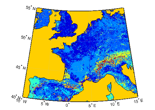
avhrrlambert
Read AVHRR data product stored in eqaazim projection
Syntax
[latgrat,longrat,Z] = avhrrlambert(region,filename)

[...] = avhrrlambert(region,filename,
scalefactor)

[...] = avhrrlambert(region,filename,
scalefactor, latlim, lonlim)

[...] = avhrrlambert(region,filename,
scalefactor, latlim, lonlim, gsize)

[...] = avhrrlambert(region,filename,
scalefactor, latlim, lonlim, gsize,precision)
Description
[latgrat,longrat,Z] = avhrrlambert( reads
data from an Advanced Very High Resolution Radiometer (AVHRR) data
set with a nominal resolution of 1 km that is stored in the Lambert
Equal Area Azimuthal projection. Data of this type includes the Global
Land Cover Characteristics (GLCC). region,filename)region specifies
the coverage of the file. Valid regions are listed in the following
table. filename is a string specifying
the name of the data file. Z is a geolocated data
grid with coordinates latgrat and longrat in
units of degrees. A scale factor of 100 is applied to the original
data set such that Z contains every 100th point
in both X and Y.
| Region Specifiers |
|---|
'a' or 'asia' |
'af' or 'africa' |
'ap' or 'australia/pacific' |
'e' or 'europe' |
'na' or 'north america' |
'sa' or 'south america' |
[...] = avhrrlambert( uses the integer region,filename,
scalefactor)scalefactor to
downsample the data. A scale factor of 1 returns every point. A scale
factor of 10 returns every 10th point. The default value is 100.
[...] = avhrrlambert( returns data for the specified
region. The result may extend somewhat beyond the requested area.
The limits are two-element vectors in units of degrees, with region,filename,
scalefactor, latlim, lonlim)latlim in
the range [-90 90] and lonlim in
the range [-180 180]. If latlim and lonlim are
empty, the entire area covered by the data file is returned. If the
quadrangle defined by latlim and lonlim (when
projected to form a polygon in the appropriate Lambert Equal Area
Azimuthal projection) fails to intersect the bounding box of the data
in the projected coordinates, then latgrat, longrat,
and Z are empty.
[...] = avhrrlambert( controls the size of
the graticule matrices. region,filename,
scalefactor, latlim, lonlim, gsize)gsize is a two-element
vector containing the number of rows and columns desired. If omitted
or empty, a graticule the size of the grid is returned.
[...] = avhrrlambert( reads
a data set with the integer region,filename,
scalefactor, latlim, lonlim, gsize,precision)precision specified.
If omitted, 'uint8' is assumed. 'uint16' is
appropriate for some files. Check the metadata (.txt or
README) file in the ftp folder for specification of the file format
and contents.
Background
The United States plans to build a family of satellite-based sensors to measure climate change under the Earth Observing System (EOS) program. Early precursors to the EOS data are the data sets produced by NOAA and NASA under the Pathfinder program. These are data derived from the Advanced High Resolution Radiometer sensor flown on the NOAA Polar Orbiter satellites, NOAA-7, -9, and -11 with a spatial resolution of about 1 km. The data from the AVHRR sensor is processed into separate land, sea, and atmospheric indices. Land area data is processed to a nondimensional vegetation index or land cover classification and stored in binary files in the Plate Carrée, Goode, and Lambert Equal Area Azimuthal projections. Sea data is processed to surface temperatures and stored in HDF formats. This function reads land cover data for the continents saved in the Lambert Equal Area Azimuthal projection at 1 km.
Examples
Tips
This function reads the binary files as is. You should not use byte-swapping software on these files.
The AVHRR project and data sets are described in and provided by various U.S. Government Web sites.
Version History
Introduced before R2006a

