scirclui
(Removed) GUI to display small circles on axesm-based
map
The scirclui function has been removed. Use the scircleg function instead.
Activation
scirclui
scirclui(h)
Description
scirclui activates the Define Small Circles dialog box for adding
small circles to the current axesm-based map.
scirclui(h) activates the Define Small Circles dialog box for
adding small circles to the axesm-based map specified by the axes
handle h.
Controls
Define Small Circles dialog box for one-point mode
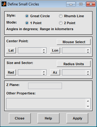
The Style selection buttons are used to specify whether the circle radius is a constant great circle distance or a constant rhumb line distance.
The Mode selection buttons are used to specify whether one point or two points are to be used in defining the small circle. If one-point mode is selected, a center point, radius, and azimuth are the required inputs. If two-point mode is selected, a center point, and perimeter point on the circle are the required inputs.
The Center Point controls are used in both one-point and two-point mode. The Lat and Lon edit boxes are used to enter the latitude and longitude of the center point of the small circle to be displayed. These values must be in degrees. To display more than one small circle, a vector of values can be entered, enclosed in brackets in each edit box. Pushing the Lat or Lon button brings up an expanded edit box for easier entry of long vectors. The Mouse Select button is used to select a center point by clicking the displayed map. The coordinates of the selected point then appear in the Lat and Lon edit boxes and can be modified. The coordinates appear in degrees, regardless of the angle units defined for the current map projection.
The Circle Point controls are used only in two-point mode. The Lat and Lon edit boxes are used to enter the latitude and longitude of a point on the perimeter of the small circle to be displayed. These values must be in degrees. To display more than one small circle, a vector of values can be entered, enclosed in brackets in each edit box. Pushing the Lat or Lon button brings up an expanded edit box for easier entry of long vectors. The Mouse Select button is used to select a perimeter point by clicking the displayed map. The coordinates of the selected point then appear in the Lat and Lon edit boxes and can be modified. The coordinates appear in degrees, regardless of the angle units defined for the current map projection.
The Size and Sector controls are used only in one-point mode. The Radius Units button brings up a Define Range Units dialog box, which allows for modification of the small circle radius units and the normalizing geoid. The Rad edit box is used to enter the radius of the small circle in the proper units. The Arc edit box is used to specify the sector azimuth, measured in degrees, clockwise from due north. If the entry is omitted, a complete small circle is drawn. When entering radius and arc data for more than one small circle, vectors of values, enclosed in brackets, are entered in each edit box. Pushing the Rad or Arc button brings up an expanded edit box for that entry, which is useful for entering long vectors.
The Z Plane edit box is used to enter a scalar value that specifies the plane in which to display the small circles.
The Other Properties edit box is used to specify
additional properties of the small circles to be projected, such as
'Color','b'. Character vector entries must be enclosed in quotes.
Pressing the Apply button accepts the input data and displays
the small circles on the current axesm-based map.
Pressing the Cancel button disregards any input data and closes the Define Small Circles dialog box.
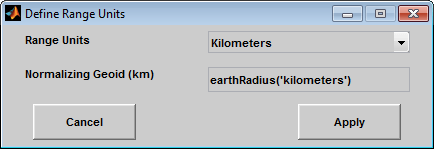
This dialog box, available only in one-point mode, allows for modification of the small circle radius units and the normalizing geoid.
The Radius Units pull-down menu is used to select the units of the small circle radius. The unit selected is displayed near the top of the Define Small Circles dialog box, and all latitude and longitude entries must be entered in these units. Users must also be sure to specify the normalizing geoid in the same units. If radians are selected, it is assumed the radius entry is a multiple of the radius used to display the current map, as defined by the map geoid property.
The Normalizing Geoid edit box is used modify the
radius used to normalize the small circle radius to a radian value, which is necessary
for proper calculations and map display. This entry must be in the same units as the
small circle radius. If the small circle radius units are in radians, then the
normalizing geoid must be the same as the geoid used for the current
axesm-based map.
Pressing the Cancel button disregards any modifications and closes the Define Radius Units dialog box.
Pressing the Apply button accepts any modifications and returns to the Define Small Circles dialog box.