craster
Craster Parabolic Projection
Classification
Pseudocylindrical
Identifier
craster
Graticule
Central Meridian: Straight line half as long as the Equator.
Other Meridians: Equally spaced parabolas intersecting at the poles and concave toward the central meridian.
Parallels: Unequally spaced straight parallel lines, perpendicular to the central meridian. Spacing changes very gradually and is greatest near the Equator.
Poles: Points.
Symmetry: About the central meridian or the Equator.
Features
This is an equal-area projection. Scale is true along the 36º46' parallels and is constant along any parallel and between any pair of parallels equidistant from the Equator. Distortion is severe near the outer meridians at high latitudes, but less so than the Sinusoidal projection. This projection is free of distortion only at the two points where the central meridian intersects the 36º46' parallels. This projection is not conformal or equidistant.
Parallels
For this projection, only one standard parallel is specified. The other standard parallel is the same latitude with the opposite sign. The standard parallel is by definition fixed at 36º46'.
Remarks
This projection was developed by John Evelyn Edmund Craster in 1929; it was further developed by Charles H. Deetz and O.S. Adams in 1934. It was presented independently in 1934 by Putnins as his P4 projection.
Example
landareas = shaperead('landareas.shp','UseGeoCoords',true);
axesm ('craster', 'Frame', 'on', 'Grid', 'on');
geoshow(landareas,'FaceColor',[1 1 .5],'EdgeColor',[.6 .6 .6]);
tissot;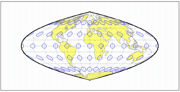
Version History
Introduced before R2006a